


The Soqotra
Archipelago
The Soqotra Archipelago (also spelled ‘Socotra’), politically part of Yemen, lies at the junction of the Gulf of Aden and the main basin of the Indian Ocean at N 12°06’ 12°42’ and E 52°03’ 54°32’ (Miller and Morris 2004), just to the east of the Horn of Africa (Fig. 1). It thus belongs ecologically, culturally, and politically to the wider Arabian region.
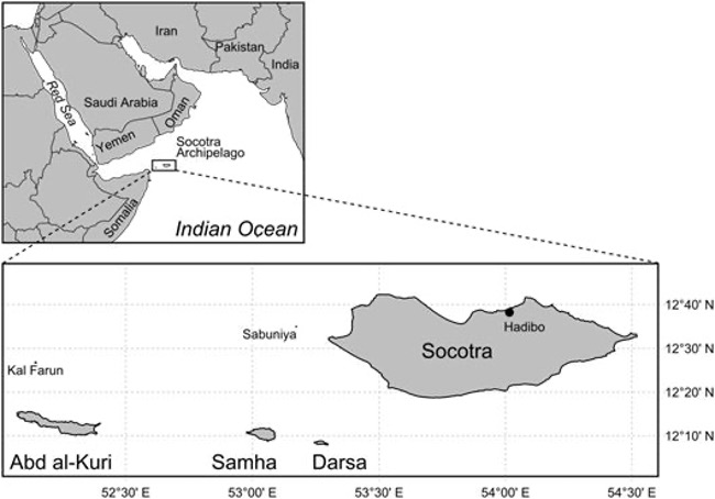
1 ZAJONZ, U. (2022). Kumulative Dissertationsschrift (PhD Dissertation), Universität Rostock. Coastal Fishes of the Socotra Archipelago – Diversity and Biogeography.
Geography and Climate
The Archipelago measures about 250 km in length and encompasses four islands, Soqotra, Abd al-Kuri, Samha and Darsa, and two rocky islets, Kal Farun and Sabuniyah (Figs. 1 2). Its westernmost island Abd al-Kuri is separated from the Somalian coast by the so-called Soqotra Passage, a trench of 910 m depth and only 105 km width. A distance of 380 km and a depth of over 4,000 m across the Gulf of Aden lie between the Archipelago and Ras Fartak, the nearest point on the mainland of Yemen (Beydoun and Bichan 1970; Fischer, Schott and Stramma 1996; Cheung and DeVantier 2006). Soqotra, the main island of the Archipelago has a maximum length of 133 km, a maximum width of 43 km and covers an area of approximately 3,600 km², representing the second largest island of the Western Indian Ocean (WIO) after Madagascar. With an area of 162 km² Abd al-Kuri is the second largest island of the group, followed by Samha with 41 km² in area, and Darsa with only 17 km² in area. Samha and Darsa are also known as “the Brothers” (Cheung and DeVantier 2006). They share a shallow geological platform with Soqotra Island, the ‘Soqotra horst’, from which Abd al-Kuri is isolated by deeper waters (Fischer, Schott and Stramma 1996; Krupp, Apel and Zajonz 2002; Miller and Morris 2004; Cheung and DeVantier 2006; Krupp and Zajonz 2009).
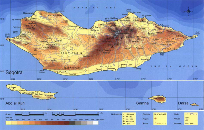
Soqotra Archipelago is largely made up of Precambrian rocks and Cretaceous to Cenozoic sediments and can be subdivided into three geomorphologic zones: granitic mountains (Fig. 3a), limestone plateaus (Fig. 3b), and predominantly alluvial coastal and inland plains (Popov 1957, Gwynne 1968; in Krupp, Apel and Zajonz 2002). The pronounced relief of Soqotra Island is dominated by the Haghir Mountains in the central north which consist of a peralkaline granite core and rise up to 1,550 m a.s.l. Karst plateaus at 300 800 m are drained by numerous wadis and subterraneous aquifers (Kossmat 1907; Kopp 1999; Fleitmann et al. 2004; Fediuk and Sebesta 2005), with limestone tables often forming steep coastal escarpments (De Geest 2006). The coastal plains are especially wide in the Momi area, a huge drainage mouth in the North, and the Nogid, a vast arid, sandy area in the South (Kopp 1999; Cheung and DeVantier 2006).
The Archipelago, situated in the northern tropics at about 12 degree latitude, is subject to a maritime-dominated marginally tropical, arid to semi-arid climate (Kopp 1999), underscored by mean annual rainfall of 216 mm and mean annual temperatures of 28.9 °C (in the 2002 to 2006 period, Scholte and De Geest 2010). It is strongly influenced by the Intertropical Convergence Zone (ITCZ) and its shifts (Fig. 4), resulting in the alternating monsoon seasons in the northern Indian Ocean and the related wind and precipitation patterns (Fleitmann et al. 2004; van Rampelbergh et al. 2013).
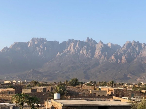
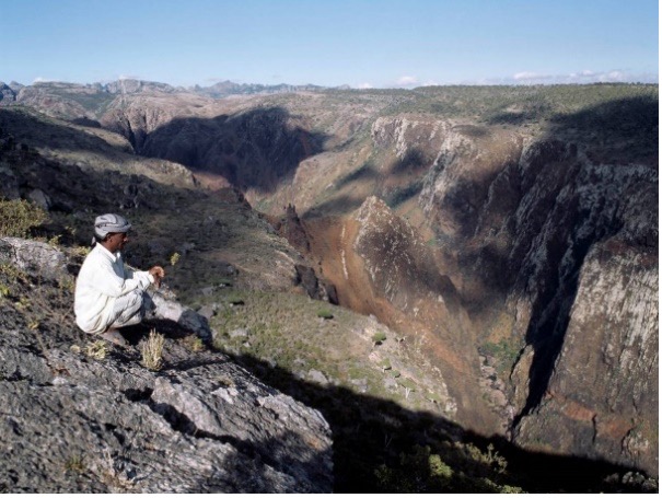
The terrestrial and marine ecosystems are thus subject to a seasonally highly variable environment: the weak and wet winter or north-east monsoon (November into February), preceded by the ITCZ passage in southward direction, and the forceful and dry summer or south-west monsoon (May into September), preceded by the ITCZ passage in northward direction (Kemp 1998; Fleitmann et al. 2004; Klaus and Turner 2004; Fleitmann et al. 2007; Scholte and De Geest 2010; van Rampelbergh et al. 2013).
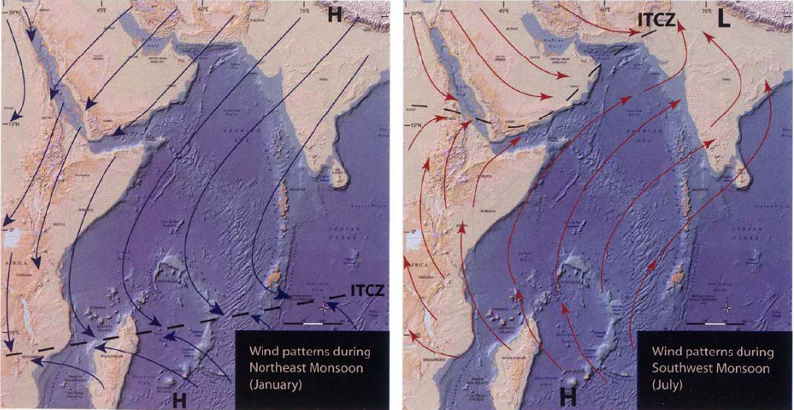
As the ITCZ steadies over the Arabian Peninsula the summer months are dominated by very strong dry south-west winds. As the ITCZ moved southward again, the winter months bring north-east winds of much lower intensity and rainfall predominantly to the eastern parts (Naumkin 1993; Kopp 1999; Miller and Morris 2004; Cheung and DeVantier 2006). The annual mean daily rainfall, measured over a five year period at ~440 m altitude, was 1.1 mm, yet with a high variation ranging between 0 mm and 208 mm. The mean monthly air temperatures on the coastal plains range from 23 °C to 35 °C between the coolest (December to February) and the hottest months of the year (April to May, followed by March and November), with mean annual minima of 17 °C to 18 °C, mean annual maxima of 37 °C, and daily maxima of up to 43 °C (Mies and Beyhl 1998; Kopp 1999; Culek, M., Kral, K. et al. 2006).
The population size was ~60,000 in 2010 (Zajonz, Deodatus and Al-Harrani 2010; Scholte, Al-Okaishi and Suleyman 2011), and has likely grown to ~70,000 80,000 inhabitants to date (UNEP 2015; Zajonz, personal observation); the vast majority of whom are concentrating in the coastal areas of Soqotra Island (Stein and Stein 1999; Miller and Morris 2004; Cheung and DeVantier 2006; Zajonz, personal observation). The Socotri populace traditionally consists of two groups: the ‘Bedu’ (or Joboliyah) which are pastoralists of the mountains and island interior, and the ‘Shahriyah’, representing the coastal population (Stein and Stein 1999; Morris 2002). The latter depend on a productive artisanal fisheries which sustains the livelihoods of some 5,000 fisher families, thus a total of 30,000 to 40,000 people (Nichols 2001; Reid et al. 2002; adjusted).
Geological History and Biodiversity
The Soqotra Archipelago is a continental island group, forming a platform that rests on the crust of the Somali Plate (Fleitmann et al. 2004). It once formed part of the Gondwana Continent and broke away from it during the Cretaceous at about the same time as India and Madagascar (100 90 Ma ago). Since the separation of the Arabian Peninsula from the African Plate during the early Paleogene (66 56 Ma ago), Soqotra had no terrestrial connection with Africa either. Prior to the onset of the resumed rifting of the Gulf of Aden during the Oligocene to Miocene, starting ~31 Ma ago, the Archipelago was located close to the present day Hallaniyat Islands (Kuria Muria) at the Dhofar coast of Oman (Fleitmann et al. 2004; Bosworth, Huchon and McClay 2005). Possibly from 21 20 Ma ago onwards (Beydoun and Bichan 1970), but at least from ~15 Ma ago onwards during the mid-Miocene (Fleitmann et al. 2004) the island group has remained above sea level and isolated from all surrounding mainland coasts, including Arabia. An instructive summary of Soqotra’s geological history is found in Cheung and DeVantier (2006).
Its long history of geological isolation and remoteness warranted large parts of its terrestrial flora and fauna an independent evolutionary history in terms of speciation, richness and assemblage composition (Mies 1999; Wranik 1999; Cheung and DeVantier 2006; Krupp and Zajonz 2009). The Archipelago is therefore globally recognized for its impressive biodiversity and high levels of endemism, which underpinned the designation of the entire island group by the United Nations Education, Scientific and Cultural Organization (UNESCO) as a Man and Biosphere Reserve in 2003 (Di Micco Santo and Zandri 2004) and natural World Heritage Site (WHS) in 2008 (Miller and Morris 2004; Scholte, Al-Okaishi and Suleyman 2011; Van Damme and Banfield 2011; UNESCO 2021).
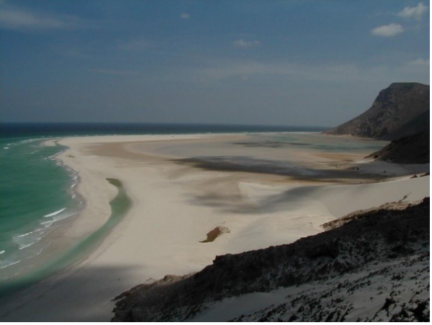
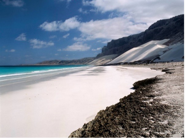
The Archipelago’s public perception as the “Galapagos of the Indian Ocean” (Sohlmann 2004) seems to allude primarily to the diversity of its terrestrial ecosystems. The coastal and marine ecosystems (Fig. 5), however, are also highly diverse and unique (Krupp, Apel and Hariri 2002; Cheung and DeVantier 2006), as will be detailed in the sections 1.2.2 and 1.3.2 3.
A key requirement for the designation as WHS was the legal promulgation of the Soqotra Conservation Zoning Plan (SCZP) in the year 2000 (Yemen 2000), including all coastal areas (Krupp and Klaus 2000). The Archipelago was also included in PERSGA’s regional network of important Marine Protected Areas (Haddad et al. 2001; Gladstone, Krupp and Younis 2003). In 2007, Diduah (also ‘Detwah’) Lagoon on Soqotra Island was nominated Yemen’s first Ramsar Site (UNESCO-Ramsar 2021). The Archipelago was the first marine WHS in the Arabian Region and, to date, represents one of only three natural WHS in the Indian Ocean (besides Aldabra Atoll, Seychelles, and Sanganeb-Dungonab, Sudan) (Scholte, Al-Okaishi and Suleyman 2011; Van Damme and Banfield 2011; UNEP 2015).
References
- Beydoun, Z.R. & Bichan, H.R. (1970). The geology of Socotra Island, Gulf of Aden. Geological Society, London, pp. 413-446, plates 21-29.
- Bosworth, W., Huchon, P. & McClay, K. (2005). The Red Sea and Gulf of Aden basins. Journal of African Earth Sciences, 43, 334–378.
- Cheung, C. & DeVantier, L. (Eds.) (2006). Socotra. A Natural History of the Islands and Their People. Odyssey Books & Guides, Hong Kong, 393 pp.
- Culek, M., Kral, K., Habrova, H., Madera, P., Pavlis, J. & Adolt, R. (2006). Socotra’s Annual Weather Pattern. In: Cheung, C. & DeVantier, L. (Eds.). Socotra. A Natural History of the Islands and Their People. Odyssey Books & Guides, Hong Kong, pp. 42–45.
- De Geest, P. (Ed.) (2006). Soqotra Karst Project (Yemen), 2000-2004. Berliner Höhlenkundliche Berichte (20). Speläoclub (caving club) Berlin, Berlin.
- Di Micco Santo, T. de & Zandri, E. (2004). Main features of the Socotra Archipelago and ongoing conservation efforts. Fauna of Arabia, 20, 9–26.
- Fediuk, F. & Sebesta, J. (2005). Winning process in the formation of slope-debris patterns of Soqotra Island, Yemen. Zprávy o geologichkych vyzkumech v roce (Geoscience research reports), 148–149.
- Fischer, J., Schott, F. & Stramma, L. (1996). Currents and transports of the Great Whirl-Socotra Gyre system during the summer monsoon, August 1993. Journal of Geophysical Research: Oceans, 101, 3573–3587.
- Fleitmann, D., Burns, S.J., Mangini, A., Mudelsee, M., Kramers, J., Villa, I. et al. (2007). Holocene ITCZ and Indian monsoon dynamics recorded in stalagmites from Oman and Yemen (Socotra). Quaternary Science Reviews, 26, 170–188.
- Fleitmann, D., Matter, A., Burns, S., Al-Subbary, A. & Al-Aowah, A. (2004). Geology and Quaternary climate history of Socotra. Fauna of Arabia, 27–32.
- Kemp, J.M. (1998). Zoogeography of the coral reef fishes of the Socotra Archipelago. Journal of Biogeography, 25, 919–933.
- Klaus, R. & Turner, J.R. (2004). The marine biotopes of the Socotra Archipelago. Fauna of Arabia, 20, 45–115.
- Kopp, H. (1999). Abiotische Geofaktoren. In: Wranik, W. (Ed.). Sokotra. Mensch und Natur. Dr. L. Reichelt Verlag, Wiesbaden, pp. 3–22.
- Kossmat, F. (1907). Geologie der Inseln Sokotra, Semha und Abd el Kuri. Denkschriften der Kaiserlichen Akademie der Wissenschaften in Wien, 71 (1), 1–62.
- Krupp, F. & Zajonz, U. (2009). Erforschung und Management der biologischen Vielfalt des Sokotra Archipels. Jemen-Report, 40, 49–54.
- Krupp, F., Apel, M. & Zajonz, U. (2002). Meeresbiologische Untersuchungen im Sokotra-Archipel (Jemen). Natur und Museum (Frankfurt am Main), 132, 273–294.
- Mies, B. (1999). Flora und Vegetation der Insel Sokotra. In: Wranik, W. (Ed.). Sokotra. Mensch und Natur. Dr. L. Reichelt Verlag, Wiesbaden, pp. 23–80.
- Mies, B.A. & Beyhl, F.E. (1998). The Vegetation Ecology of Soqotra. In: Dumont, H. (Ed.). Proceedings of the First International Symposium on Soqotra Island: Present and Future, Aden 1996. United Nations Publications, New York.
- Miller, A.G. & Morris, M. (2004). Ethnoflora of the Soqotra Archipelago. Royal Botanic Garden, Edinburgh, i-xvi, 1-759.
- Naumkin, V.V. (1993). Island of Phoenix. An ethnographic study of the people of Socotra. Ithaca Press, Reading, 421 pp.
- Nichols, P. (2001). UNDP-GEF Project Conservation and Sustainable Use of Biodiversity of Socotra Archipelago. Fisheries Management Plan for the Socotra Island Group, 130 pp.
- Reid, A., Macfadyen, G., Grinyer, T. & Al-Sakaf, H. (2002). Socotra Archipelago Master Plan 2001-2010. WS Atkins International Ltd., 56 pp.
- Scholte, P. & De Geest, P. (2010). The climate of Socotra Island (Yemen). Journal of Arid Environments, 74, 1507–1515.
- Scholte, P., Al-Okaishi, A. & Suleyman, A.S. (2011). When conservation precedes development. Oryx, 45, 401–410.
- Stein, L. & Stein, H. (1999). Die Bewohner der Insel Sokotra. In: Wranik, W. (Ed.). Sokotra. Mensch und Natur. Dr. L. Reichelt Verlag, Wiesbaden, pp. 195–226.
- UNESCO (2021). World Heritage List. Socotra Archipelago. Online repository. Available from: https://whc.unesco.org/en/list/1263
- Van Damme, K. & Banfield, L. (2011). Past and present human impacts on the biodiversity of Socotra Island (Yemen). Zoology in the Middle East, Supplementum 3, 31–88.
- van Rampelbergh, M., Fleitmann, D., Verheyden, S., Cheng, H., Edwards, L., De Geest, P. et al. (2013). Mid- to late Holocene Indian Ocean Monsoon variability. Quaternary Science Reviews, 65, 129–142.
- Wranik, W. (1999). Die Tierwelt der Insel Sokotra. In: Wranik, W. (Ed.). Sokotra. Mensch und Natur. Dr. L. Reichelt Verlag, Wiesbaden, pp. 81–182.
- Zajonz, U., Deodatus, F. & Al-Harrani, G. (2010). Yemen Strategic Environmental Assessment of Coastal Zone Management. Report to the World Bank and the Environment Protection Authority, Yemen.